
HIKE 1: Gajisan Ridge Loop - 5 hours
Difficulty Rating: 3 - Intermediate
This hike begins at Seongnamsa (temple) and climbs steeply up the hillside to the main ridge. From there, the path goes west past Ssalbawi, and continues to Gajisan (1,240 m).
The trailhead starts just before you walk into the temple grounds. There’s a road to the right marked with a metal sign and basic trail map (in Korean). Follow this road past a hilltop monument on the left (you’ll be going away from Seongnamsa and the mountains, which seems wrong--but it isn’t) until it meets with the trail. There the trail doubles back toward the mountains. The early part of the trail does not have signs, but it’s fairly easy to stay on the right track as the trail is well-defined most of the time. As always, look for red, pink, or yellow ribbons tied to trees if you're unsure. At places, the trail crosses a river bed (sometimes dry, sometimes not). It climbs quite steeply for about 1 hour, at which time you come out onto a dirt utility road near Gwibawi (1,117 m). Go left (west). The rocky outcropping of Ssalbawi (1,109 m) is an easy 30 minutes further and offers stunning views of the Eonyang Valley and surrounding peaks. From there it’s gentle 30-40 minute climb to the peak of Gajisan. All of the ridge hiking is quite easy and can be covered quickly, if necessary. Keep an eye out for colorful snakes (look, don't touch) and mountain toads. Unmunsan (1,118 m) is about 2 hours further west from Gajisan.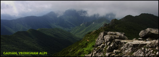
On the return trip, a heavily-eroded path leads south toward Seongnam Tunnel for about one hour. At the fork, one trail continues south to the tunnel and on to the Southern Yeongnam Alps. It's possible to hike all the way from this point and come out far south at Pyochungsa (temple) in Miryang, but it's a full-day trek. Take the eastern option instead. Another 50 minutes on the trail brings you to the paved road, just above the parking lot and Seongnamsa bus stop. This route is popular with Koreans heading up to Gajisan. It’s well-marked with non-English signs. The entire hike can be accomplished in 4 hours.
HIKE 2: Seongnamsa to Unmunsa - 5-6 hours
Difficulty Rating: not rated -
This hike follows the route of Hike 1 to Gajisan peak. From there it continues west to Araetjae Pass and on to Unmunsan (about 2 hours). Unmunsa (temple) is another 2 hours hike north.
We're looking for someone to write a description of this hike. If you've personally hiked this route and would like to contribute an account of your experience, email me at: alexzuccarelli@gmail.com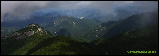
GAJISAN (가지산) Hiking Routes
![]()
Subscribe to:
Post Comments (Atom)
No comments:
Post a Comment