Of the top 25 highest accessible peaks in South Korea, 21 of them can be found in only 4 parks--Jirisan, Seoraksan, Deogyusan, and Taebaeksan. Fourteen of these are in Jirisan alone, attesting to the park's merits as a destination for serious hikers. Though South Korea's mountains are moderate in size (the highest is just under 2,000 meters) and obviously can't be compared to ranges like the Sierra Nevadas and the Rockies where there are scores of peaks over 4,000 m, they are certainly worth exploring. They also tend to be fairly steep climbs (switchbacks are uncommon) with trails starting not far above sea-level. Hiking in mid-winter can add an extra challenge to a climb, as Korea's winters are extremely harsh. Below is a list of the 25 highest peaks. Beneath about 1,450 meters, it gets difficult to rank peaks because there are just so many of them spread across the peninsula.
1 Hallasan, Jeju-do 1,950 m
2 Cheonhwangbong, Jirisan 1,915 m
3 Jungbong, Jirisan 1,875 m
4 Jeseokbong, Jirisan 1,806 m
5 Habong*, Jirisan 1,781 m
6 Banyabong, Jirisan 1,734 m
7 Daecheongbong, Seoraksan 1,708 m
8 Chotdaebong, Jirisan 1,704 m
9 Yeonghabong, Jirisan 1,667 m
10 Yeongshinbong, Jirisan 1,652 m
11 Sseoribong, Jirisan 1,642 m
12 Hyangjeokbong, Deogyusan 1,614 m
13 Jungbong, Deogyusan 1,594 m
14 Myeongsongbong, Jirisan 1,586 m
15 Taebaeksan, Taebaeksan 1,567 m
16 Birobong, Odaesan 1,563 m
17 Munsubong, Taebaeksan 1,547 m
18 Tokkibong, Jirisan 1,534 m
19 Deokpyeongbong, Jirisan 1,522 m
20 Nam Deogyusan, Deogyusan 1,507 m
21 Nogodan, Jirisan 1,507 m
22 Muryongsan, Deogyusan 1,492 m
23 Samgakbong, Jirisan 1,462 m
24 Bangtaesan 1,444 m
25 Birobong, Sobaeksan 1,439 m
*There is no official trail to this peak.
POPULAR LESSER PEAKS
Manbokdae, Gurye-gun 1,437 m
Dongdaesan, Odaesan 1,433 m
Chilbulbong, Gayasan 1,433 m
Sangwangbong, Gayasan 1,430 m
Ansan, Seoraksan 1,430 m
Durobong, Odaesan 1,422 m
Yeonhwabong, Sobaeksan 1,394 m
Naesamshinbong, Jirisan 1,354 m
Noinbong, Odaesan 1,338 m
Chilbong, Deogyusan 1,305 m
Birobang, Chiaksan 1,288 m
Soetongbawi, Jirisan 1,264 m
Gajisan, Gajisan 1,240 m
Daeseungnyeong, Seoraksan 1,210 m
Shinbulsan, Yeongnam Alps 1,208 m
Palgongsan, Palgongsan 1,199 m
Unmunsan, Gajisan 1,189 m
Sajabong/Jaeyaksan, Yeongnam Alps 1,189 m
Namdaebong, Chiaksan 1,182 m
Dongbong, Palgongsan 1,155 m
Yeombulbong, Palgongsan 1,121 m
Sangunsan, Gajisan 1,114 m
Sumibong, Yeongnam Alps 1,108 m
Woraksan, Woraksan 1,093 m
Cheonjibong, Chiaksan 1,086 m
Ganweolsan, Yeongnam Alps 1,083 m
Chwiseosan, Yeongnam Alps 1,059 m
Cheonhwangbong, Songnisan 1,057 m
Hyangnobong, Chiaksan 1,043 m
Munjangdae, Songnisan 1,033 m
Birobong, Songnisan 1,032 m
Munsubong, Songnisan 1,031 m
Pagyebong, Palgongsan 991 m
Nuengdongsan, Yeongnam Alps 982 m
Eoksan, Gajisan 994 m
Kogeoribong, Yeongnam Alps 889 m
Nojeokbong, Palgongsan 887 m
Baekunsan, Gajisan 885 m
Gwanbong, Palgongsan 850 m
Baekundae, Bukhansan 836 m
Gwaneumbong, Gyeryongsan 816 m
Geumeungwangi, Juwangsan 812 m
Mangyeongdae, Bukhansan 799 m
Sambulbong, Gyeryongsan 775 m
Sinseonbong, Naejangsan 763 m
Tohamsan, Gyeongju 745 m
Dobongsan, Bukhansan 740 m
Yeoncheonbong, Gyeryongsan 738 m
Juwangsan, Juwangsan 721 m
Gachibong, Naejangsan 717 m
Nojeokbong, Bukhansan 716 m
Yeonjibong, Naejangsan 670 m
Manghaebong, Naejangsan 650 m
Seoraebong, Naejangsan 622 m
Palibong, Geumjangsan 616 m
Bulchulbong, Naejangsan 610 m
Namsan, Gyeongju 494 m
The HIGHEST MOUNTAIN PEAKS in South Korea
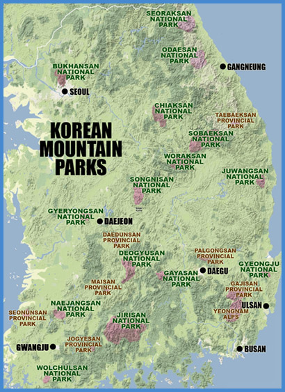
KOREA'S NATIONAL PARKS
As an international hiking destination, South Korea has been a bit overlooked. This is mainly due to the lack of English information available to foreign hikers and climbers, but also a product of Korea's underdeveloped foreign tourist industry. Most of the national parks in Korea have simple English maps or brochures, but the practical information is limited and takes a backseat to the nation's rather tiresome habit of boasting and exaggerating about everything it has to offer. This turns a lot of Westerners off, which is unfortunate, because Korea does have much to offer the motivated hiker. It's an extremely rugged country overall, with small to medium-sized mountains covering 75% of the nation's land area.
Though small in area, the Korean national parks are diverse and beautiful. There are a total of 20 national parks in Korea (including 16 mountain parks), making up an impressive 3.7% of Korea's total land area. The mountain parks are scattered throughout the peninsula, with Seoraksan the farthest north and Wolchulsan the farthest south. Mountain ranges are often the basis of provincial boundaries, and consequently 7 of the 16 parks lie on the borderlines of the provinces and can be accessed from multiple directions. Jirisan, the largest and oldest of the national parks, is found at the nexus of three provinces--South Gyeongsang, South Jeolla, and North Jeolla--and offers the most serious hiking in the country.
Every park is unique, ranging from smooth, rolling hills and valleys to ragged, craggy ridges and sheer, rocky cliffs. Most the parks offer a wide variety of easy to moderate day hikes and a few longer, more strenuous routes. The longest and most strenuous route in Korea crosses the entire Jirisan range and takes about 3 days (we did it in 2 days, but it was pretty brutal). Camping facilities, though fairly undeveloped, are available at some parks, but most are only open during the peak summer season. Some of the large parks, such as Jirisan and Seoraksan, have mountain shelters where long-distance trekkers can crash. None of the parks in Korea allow backcountry camping, which is probably wise considering the number of local visitors these parks get. To further protect the natural geography, the Korean National Park Service (KNPS) temporarily closes trails on a rotating basis to allow wildlife to recover.
OFFICIAL KOREAN NATIONAL PARK WEBSITE (ENGLISH)
CURRENT TRAIL CLOSURES (ENGLISH)
As an American who has hiked extensively in Korea's national parks, I'm continually surprised by the number of foreign residents I meet who have never explored the park system. And yet, it's understandable, considering the lack of easily accessible, accurate, English language information. Before setting off into the hills, most people want to know what they're getting into, how to get there, how long it will take, how much it will cost, and where to stay. Random exploration is great if you have unlimited time and resources, but not if you only have 48 precious hours of weekend freedom before you start work again on Monday morning.
The purpose of this site is to provide people with the information they need to enjoy Korea's mountains fully. During the two years I lived in Korea, I gathered as much information as I could about hiking in the parks, and much of it is posted here. Now that I'm no longer living in Korea, I'm opening the site up to the rest of the hiking community. What we need here are detailed summaries of the different hiking and mountaineering options in Korea, along with detailed trail maps, transportation info linking the parks with major urban centers, photos, etc. You can help KOREA IN THE CLOUDS by saving all the maps and pamphlets you get when you visit the parks and by taking note of trail closures you encounter, changes in fees, the operating capacity of mountain shelters, and anything else that would be of interest to hikers. Then pass that on to me at alexzuccarelli@gmail.com so it can be added to the blog. Of great worth are verified hiking distances from point to point, as these are not shown on currently available maps (except those I've created).
I hope you all find this blog to be helpful and accurate. Please let me know, if there errors that need to be corrected. alexzuccarelli@gmail.com